Like most Americans, I’ve woken up over the last few days distressed and saddened by the news of fires spreading across my home state of California.
As of this writing, the death toll from fires has risen to 42. For perspective, that’s close to the number of fatalities from Hurricane Michael, one of the biggest storms to ever hit the US mainland.
And sadly, that number may well grow as officials are confirming that
over 200 people are still missing.
All told, these simultaneous fires now equal the deadliest on record in the state. California.gov keeps an active map of blazes (there are at least 14 of them at the moment) and as you can see, there’s hardly a region left untouched:
[caption id="attachment_27918" align="alignnone" width="952"]
 Map of Current Wild Fires in California including Woolsey, Camp and Hill fires
[/caption]
Here’s a brief look at how these fires developed, where they are now, and what experts are saying about the prospects of containment.
A sudden eruption
The three most destructive fires have been Camp Fire in Northern California followed by the Woolsey and Hill fires in Southern California. These blazes ignited on the same day: Thursday, November 8. They were largely due to a dry landscape and
high winds originating in the jet stream that are common this time of year. The conditions were perfect in nearly all parts of the state for a spontaneous combustion of historic proportions.
The deadliest of these, the Camp Fire (named after Camp Creek Road) started around sunrise in Butte County in Northern California. Firefighters were on the scene quickly, but because of dry conditions and high winds (kicking up to as much as 60 miles per hour), they could do little to prevent it from spreading. As a result,
an evacuation order was put in place for Paradise, a town in Butte County not far from where the Camp Fire originated.
[caption id="attachment_27919" align="alignnone" width="638"]
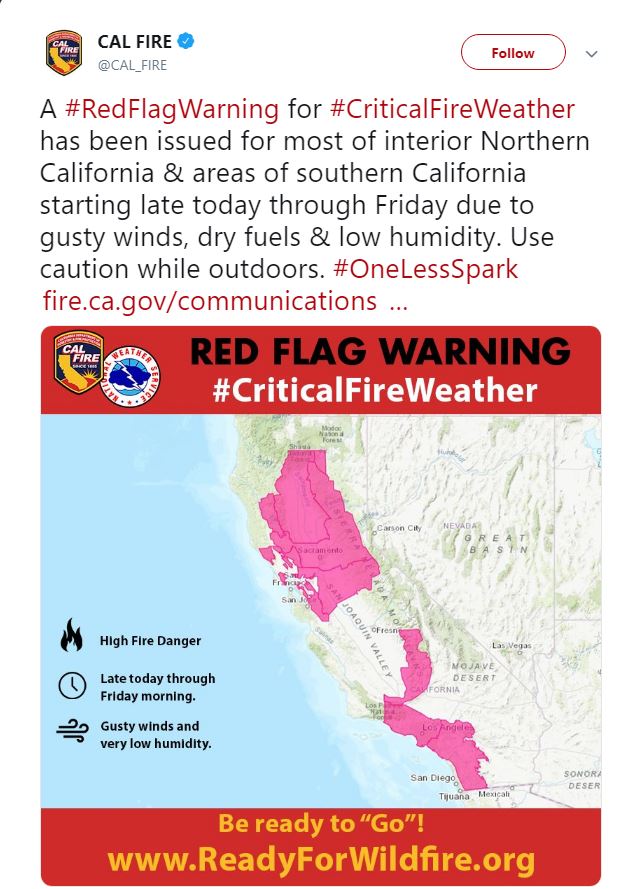 Red Flag Warning issued for high fire danger in most of California
[/caption]
Most of the 26,000 plus residents in Paradise evacuated as soon as the order was issued but quickly
found themselves trapped in bumper to bumper traffic that sat at a standstill for hours. Meanwhile, the fire reached city limits and turned entire neighborhoods into tunnels of flame.
Panicked, many residents were forced to exit their cars and flee on foot. Some didn’t get out. As of today, the death toll in Paradise stands at 42—seven of the victims died in their vehicles.
Emergency teams continue to sift through the remains of more than 6,700 homes and businesses destroyed in the town of Paradise, and at least 228 people were still unaccounted for in a town.
The incident has now passed the 1933 Griffith Park fire for the deadliest in California history. By some estimates,
80 to 90 percent of the town is gone. With the Camp Fire only 30% contained, and high winds predicted to persist through Tuesday the 13
th, firefighters have an uphill battle to wage until Camp Fire is under control.
[caption id="attachment_27920" align="alignnone" width="1024"]
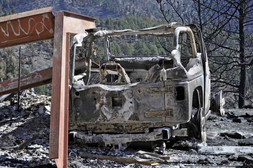 Most of the town of Paradise was burned as residents remained stuck in traffic attempting to evacuate.
[/caption]
The Woolsey Park Fire and the Hill Fire, while not as widespread as Camp Fire, are causing alarm as they burn in and around the highly populated areas of Los Angeles and Ventura counties.
The Woolsey Fire, by far the larger of the two, ignited near the Santa Susana Field Laboratory, spread south, and soon consumed large portions of the Santa Monica Mountains. Near the Pacific Coast Highway, dozens of homes have been destroyed as well as historic film sets.
With the Hill Fire nearly contained, the Woolsey fire continues to rage,
only 20% contained as of Monday. Depending on winds, the fire stands to threaten 57,000 homes after already burning through 370 structures.
The Wrong End of a Historic Trend
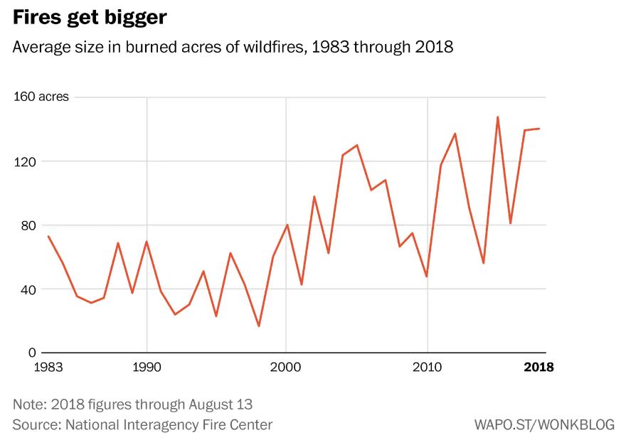
Unfortunately, these fires are not isolated events. Since at least the 1980s, there has been a startling spike in the size of wildfire disasters across the western United States. According to data collected by the National Interagency Fire Center, since 1983 the pure acreage consumed in wildfires has grown by leaps and bounds.
In 1983, for instance, 18,000 fires burned in the US and consumed a little more than 1 million acres. That trend has been on the rise from then till now. In 2015 10.1 million acres burned in the US—a tenfold increase.
The cause of this dramatic jump hasn’t been as much because there are more fires, but because fires are getting much larger, as the graph below shows:
As we look for solutions to disasters like the Woolsey and Camp fires, the question of why wildfires have grown in size doesn’t seem to have a single answer. The greatest culprit, possibly, are weather patterns, which have changed in the last few decades.
Carrie Bilbao of the National Interagency Fire Center sites 2017 as a perfect example of how conditions are ripening for wildfires. A late, wet spring that year followed by a dry, hot summer created an abundance of vegetation growth that then quickly dried out, producing massive amounts of kindling.
There is also a possible human element to this story that revolves around the way
fire containment practices has changed over the decades. Since the 1970s, the practice of natural burn forest management has grown. Fire managers now tend to allow fires to consume large swaths of land before aggressively seeking complete containment.
The idea is that fires themselves will eliminate kindling and produce a far less combustible landscape than if humans put out every blaze immediately. This common understanding that forests need to burn (and the desire to spare firefighters’ lives) has led many fire managers to take a “wait and see” approach to existing fires.
While there is debate over the best method of forest fire management, one thing is clear: there will be no easy transition back to the days of smaller, more contained fires. “You can’t just turn that switch back on,” said Brandon Collins, a research scientist with Berkeley’s Center for Fire Research and Outreach. “We might just be turning [some forests] into shrub lands.”

1 comment
Debbie
One missing key is the use of “mob grazing”—the controlled rotation of livestock through and around forests—both to help feed the animals (making their meat way healthier for people!) and to clear underbrush that burbs quickly in a fire! Also, mob grazing actually helps REVERSE DESERTIFICATION!!!!! Which CA needs desperately right now!!!!!